By Bruce Colman | 11 Dec 2019

200,000 new jobs, new zones, new precincts and more. The newly released Aerotropolis Planning Package is a giant leap forward for the key city shaping project of Western Sydney, and beyond.

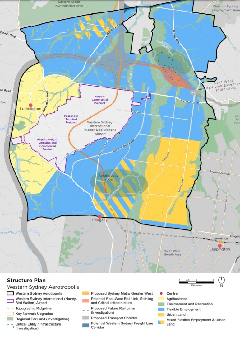
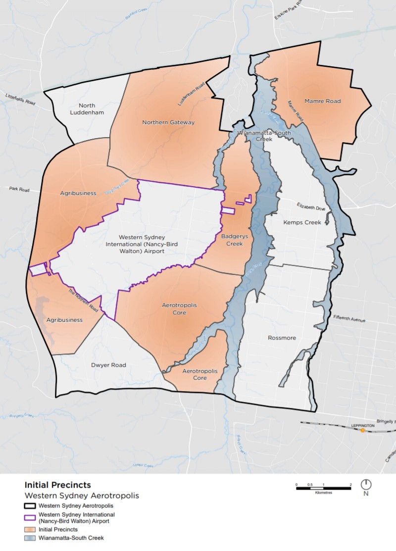
The Aerotropolis Planning Package, launched last week, is an exciting advancement in the development of the ten precincts which make up the Aerotropolis. The 11,200 hectare area is of national significance, with the anticipated 200,000 new jobs having a critical determining influence in creating the 30-minute Western Parkland City. 

The previously publicised ‘LUIIP’ label has disappeared. So, part of the challenge is keeping up with the terminology, new zones and proposed approval processes. In this article, the first of a series by Urbis, we present a plain English interpretation of how development will unfold around the $5.3 billion Western Sydney International (Nancy-Bird Walton) Airport.  

We congratulate the Western Sydney Planning Partnership in reaching this significant milestone. Getting a complex set of statutory and policy documents through eight councils, three layers of Government and multiple stakeholders is a great achievement. It is a testament to the emerging success of the Western Sydney City Deal, which has become a flagship for other emerging City Deals across the country.

The newly released Package includes:

  • A draft Aerotropolis Plan which explains the planning context
  • Draft State Environmental Planning Policy (rezoning) and Ministerial Direction
  • The draft Development Control Plan (Phase 1 of 2)

Following, we explore the new zones and precincts, and outline what to expect next.

A range of new, bespoke zones have been established for the Aerotropolis. This sets up a very flexible framework within which development can occur over the next twenty years. A SEPP discussion paper outlines the approach. 

The new Aerotropolis zones are as follows:

  • Enterprise zone: (Northern Gateway, Badgerys Creek, Aerotropolis Core) Uses which complement airport operations, which do not include residential uses.
  • Mixed use zone: Land not affected by the 20 ANEC / ANEF and above in high amenity areas.  Commercial and residential uses are permitted.
  • Environment and Recreation zone: Primarily the Wianamatta-South Creek Precinct and other areas identified for conservation and biodiversity.
  • SP1 Special Activities zone: designed for the airport (Commonwealth Land).
  • SP2 Infrastructure zone: for road and rail corridors: This zone will need to be modified as corridors (particularly rail) become known.
  • Agribusiness Zone: to support high tech agribusiness, including freight logistics and horticulture.

There will be an updated Ministerial Direction which will require all Planning Proposals seeking to amend land zoned under the Aerotropolis SEPP or the respective council LEP to be consistent with the Aerotropolis plan.

The key Structure Plan diagram and related zones is shown below. 

Key Structure Plan diagram
The key Structure Plan diagram and related zones. Click to enlarge.

The Aerotropolis will be framed around a landscape-led approach, with an expansive network of green and blue corridors, while contributing to greater productivity and a significant increase in jobs for Western Sydney.

The Phase 1 Development Control Plan will promote exemplary design on land covered by the SEPP and WSAP. It will include the planning principles and objectives to achieve the vision for the Aerotropolis as well as some performance outcomes for development.

The Phase 2 Development Control Plan, proposed for mid-2020, will identify additional performance outcomes and specific development controls. There will be opportunity for proponents to prepare site specific DCP provisions where they wish to advance planning ahead of the NSW Government’s program. 

There will also be a referral mechanism to the Commonwealth to safeguard airport operations in relation to noise and the Obstacle Limitation Surfaces. This includes the use of certain cranes, development which creates windshear or development which attracts wildlife.

The draft Planning Package has resulted in the release of three additional Precincts. This partly reflects the combined ability to focus services in the area, but also the private land acquisition process which has meant that almost all the large, unfragmented land holdings are now owned by institutional investors.

There have been many representations to Government by the major landowners with a clear message that they are ready to go now. This is a big contrast to the North West and South West Growth Areas which have usually only had three active Precincts at a time. The draft Planning Package also outlines a clear process for landowners to follow should they wish to move ahead of the precinct planning process.

The additional 780 hectares of new industrial land to provide 17,000 additional jobs is a major boost to Western Sydney job creation.

The release of the draft Mamre Road Precinct and its retention within the WSEA SEPP is a significant change to the original intention of the Stage 1 LUIIP. The additional 780 hectares of new industrial land to provide 17,000 additional jobs is a major boost to Western Sydney job creation. This is a recognition by Government of the current critical shortage of accessible employment land for warehousing and distribution facilities.  

The initial and remaining Precincts are listed below. 

Initial Precincts (mid-2020) Remaining Precincts (release date to be determined)
Aerotropolis Core Dwyer Road
Agribusiness Kemps Creek
Badgerys Creek North Luddenham
Mamre Road Rossmore
Northern Gateway  
Wianamatta – South Creek  


Initial Precincts
The initial Precincts. Click to enlarge.

The next two months of community consultation, up until 28th February 2020, will be critical for the Precinct Planning phase of the Aerotropolis.

Perhaps less controversial than the Stage 1 LUIIP, the identification of a larger number of early release precincts and the clearer hierarchy of the green grids and road patterns means there is a greater opportunity for the Planning Partnership to drill down to the next level of detail in mid-2020. By that stage, the Western Sydney Airport Corporation will be well advanced in the Terminal design process, the M12 will be post exhibition and very controversial elements, such as the location of the Intermodal Terminal in Mamre Road Precinct, may be resolved.

The Plan states that by mid-2020, the following documents will be finalised:

  • Western Sydney Aerotropolis Plan
  • Aerotropolis SEPP
  • Aerotropolis Development Control Plan – Phase 1

Significantly, the Plan also states that by mid-2020, the important missing links will be exhibited, leading to finalisation by late 2020:

  • State & local infrastructure contributions plans
  • Individual Precinct Plans (including Indicative Layout Plans)
  • Aerotropolis Development Control Plan – Phase 2

Our team will continue to provide you with updates over the next two-month exhibition period.

These proposed plans may provide further detail on metro rail alignment and station locations, additional infrastructure and services sequencing and funding and any value capture mechanisms.

The release of the Western Sydney Aerotropolis Plan marks the beginning of an exciting new phase for Western Sydney and its surrounds. With it, are many opportunities and, of course, challenges. Our team will continue to provide you with updates over the next two-month exhibition period. During which we will also explore some of the themes in more depth as the intricacies of the Aerotropolis planning process become evident.

Any questions in the meantime? Get in touch with our experts.

Bruce Colman View Profile
Murray Donaldson View Profile
Christophe Charkos View Profile
David Hoy View Profile
Jacqueline Parker View Profile
Jennifer Cooper View Profile
Adrian Villella View Profile

Header image by Ross Parmly on Unsplash.